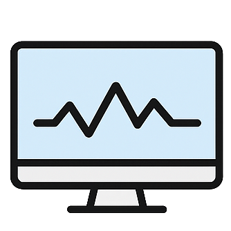
Geophysical Site Delineation
Experts at modelling the earth from surface or in boreholes for engineering tasks – servicing British Columbia and Western Canada
What we offer
45 years of experience in sub-surface modelling
Engineering Geophysics
Geotechnical, Mining, Structural, Civil, Environmental, and Hydrogeological

In-Situ or In-Lab Soil Testing
Capable of a spectrum of testing methods
Mineral Exploration
Actively pursuing and investing in new exploration technologies
Consulting and Data Processing Services
The most current industry knowledge, equipment and software
Seismic Site Class Vs30
Highly Precise Layered Shear Wave Modelling
Bedrock Mapping
3D models with overburden, weathered and competent bedrock layers
Downhole & Crosshole
Measure Vs and Vp waveforms within boreholes.
Resistivity
All electrical resistivity measurement types
Ground Penetrating Radar
High resolution mapping of the upper 10m of earth
Other Borehole Logging Methods
A plethora of tools dedicated to engineering and mining applications.
Contamination Mapping
Map pollutants, metals, objects and water intrusions.
Asphalt & Concrete Scanning
Detect voids, cracking, granular thickness, rebar, objects and utilities
Marine Geophysics
Find earth characteristics underlying water bodies